
INTS 3D Visualization System
The INTS 3D Visualization system provides out of the window bridge view, including binocular and search light functions.
INTS 3D enables the trainees under very realistic environmental conditions to rehearse visual navigation, tactical maneuvering, and perform lookout functions for optical identification of targets. INTS 3D has a 360 degree field of view with binocular functions.
INTS 3D supports up to 5 different predefined camera positions.
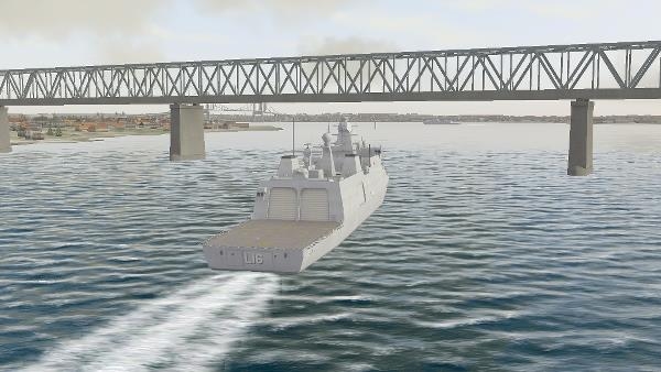
INTS image: Danish frigate passing Little Belt bridge
INTS 3D Visual Database
The INTS 3D visual terrain is generated at run-time directly from raw GIS data! No pre-generated visual database is needed. The visual terrain is generated from elevation data, imagery and vector data extracted from S-57 sea charts).
The Naval Tactical Simulator (INTS) supports terrain data from local files or from the central Map Server shared with other INTS systems like the INTS Instructor, INTS Tactical Console and the INTS Radar video simulator.
The visual terrain includes:
- Buoys, navigational landmarks and lighthouses
- Blink sequence and light characteristics according to sea charts
- Windmills, churches, chimneys and other reference points according to sea charts
- Auto generated houses and forrests from sea charts or other vector data
- Landmass with texture according to elevation data and orthophotos
The INTS 3D Visualization system is provided with low res world coverage elevation and imagery.
Visual Models
INTS 3D Visualization system includes a library of 100+ highly detailed visual models of surface, air, subsurface, land entities, life forms and cultural features. Visual models are provided with navigation ligths according to rules of the road and visual features like rotating radars.
Custom visual models are provided on request.
Configuration
The INTS 3D Visualization system is an add-on to the Naval actical Simulator (INTS) but can be used with 3rd party systems as well through its DIS and HLA interface. INTS 3D runs on standard Windows based PCs.